|
Dec 21, 2012
Wisconsin was hit by a strong blizzard on Thursday with Dane County Wisconsin being the epicenter with the highest snow amounts. Middleton and Beaver Dam, Wisconsin recorded close to 20 inches of snow. While areas further east closer to Lake Michigan picked up less amounts. Blizzard conditions were common over south central Wisconsin due to the drier snow that was easily picked up and blown around by strong 40 mph winds.
Meteorologists had been tracking this storm for a week and had projected to hit the upper Midwest. This storm was created by a strong negative tilt 500 mb trough that moved from Missouri into Indiana. The storm reached its peak near Chicago that caused the low pressure to deepen to 982 mb.
  
Rain/Snowline:
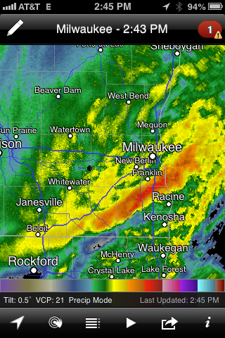
Before the storm hit, there were questions on where the rain/snow line would set up during the onset of the storm. It had orientated itself from southwest to northeast across, Rock, Jefferson and Dodge counties for a time. Around 1:45pm the rain/snow line started to gradually move east causing the rain to change to a heavy, wet snow across Washington, Ozaukee, Waukesha and Walworth counties. It had cleared most of southeast Wisconsin by 5:00pm, including Milwaukee. By that time, the heaviest snow had already fallen. On the radar, you can tell visually see the rain/snow line is located.
Snow Amounts:
Here are some snow amounts courtesy of NWS Milwaukee Sullivan's Website.
20.1" Beaver Dam, Wisconsin
19.5" Middleton, Wisconsin
15.1" Lake Mills, Wisconsin
3.0" Waukesha, Wisconsin (3 miles SE)
2.0" West Allis, Wisconsin
2.5" Racine, Wisconsin
Make sure to browse the news section for additional U.S. and Wisconsin weather news information.
|
